
Allegheny Aqueduct in Berks County, PA
, by John Urbanski, 10 min reading time
, by John Urbanski, 10 min reading time
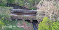
The Allegheny Aqueduct, also known as Gibraltar Aqueduct, is a historic stone aqueduct located at Robeson Township in Berks County, Pennsylvania. It was built in 1824. It was built as part of the Schuylkill Navigation Company canal system to carry canal boats across the Allegheny Creek. It is supported by a stone arch bridge structure with five spans.

From the historical marker:

Allegheny Aqueduct and the Schuylkill Navigation System.
Built by the Schuylkill Navigation Company in 1824, under the direction of engineer Ephriam Beech, the Allegheny Aqueduct crosses the Allegheny Creek and rests on the Girard Canal Section of the Navigation.
Measuring 112 feet long and 36 feet wide at the waterline, this "bridge for boats" provided an important method for shipping goods and products for over 100 years, 1824 - 1931.
The Schuylkill navigation System remained open for recreation until closing completely in 1945.
Listed under the National Register of Historic Places in 1983, the aqueduct was restored in 1989 by Berks County Commissioners with assistance provided by the Pennsylvania Department of Environmental Resources, in cooperation with the Schuylkill River Greenway Association and the Birdsboro Municipal Authority.

National Register of Historic Places Inventory Nomination Form - Statement of Significance.
The Allegheny Aqueduct was in operation from 1824 to 1928 as part of the Schuylkill Navigation Company Canal. ,It was used for another 19 years as part of a water supply system. The Allegheny Aqueduct is significant because this structure embodies the evolution of early canals in Pennsylvania and the eastern United States. The structure reflects the progress in technology, engineering and construction methods for canals; a transition in the development of transportations systems; and the development of the Pennsylvania hinterlands.
The history of the aqueduct reflects the economic progress of commerce and industry: the development of agriculture and coal mining; and earlier methods of capital financing. The aqueduct was part of a canal system that extended its influence from Philadelphia, northward to the coal regions and westward to· the farmlands and the Susquehanna Valley. The system influenced the growth of many villages and important industrial centers such as, Reading, Pottstown, Norristown, Pottsville, Lebanon and Philadelphia. The aqueduct is particularly significant because of its uniqueness and rarity. When built, the Allegheny Aqueduct was the second longest (spanning 112 feet) in the Schuylkill Canal system, being only slightly smaller than the Hay Creek Aqueduct at Birdsboro. Today, it is the only structure of its type from the Schuylkill Canal which remains intact. All other aqueducts have been demolished or have collapsed from deterioration. It is also rare, because the surrounding site has remained unspoiled by intruding development.
The Canal: The aqueduct was part of the Schuylkill Navigation Company canal system. This particular segment of the system was known as the Girard Canal and was named for Stephen Girard of Philadelphia, who, in February, 1823, loaned money to the Schuylkill Navigation Company to construct 22 miles of the canal from a point near the village of Limerick, northwestward to Poplar Neck, a point in the Schuylkill River located a few miles downstream from Reading.
The Girard Canal paralleled the southwest shore of the Schuylkill River. This section of the River is relatively flat, but contains a number of shallows and small rapids., The canal by-passed this stretch of the River, utilizing locks at Birdsboro, near Pottstown and at Limerick. At Limerick, the canal boats returned to the deep slack water. of the Schuylkill River That Portion of the Girard Canal between Birdsboro and Poplar Neck was known as Six Mile Level. In addition to the lock structures, aqueducts and culverts of varying sizes had to be built, in order to cross the tributary streams of the Schuylkill. There were about 17 aqueduct structures along the Girard Canal.
Thomas Oakes was the engineer who layed out the Girard Canal. In the fall of 1821, the Board of the Schuylkill Navigation Company authorized advertisement for contractors. Before the Girard Canal could be completed, Thomas Oakes died in the summer of 1823. Oakes was replaced by Henry King, but he died in the fall of that same year. These events coupled with construction difficulties, delayed the completion of the canal.
On July 3, 1824, the Schuylkill Navigation Company proudly started to fill the Girard Canal with water, in preparation for the first voyage to Philadelphia. On July 5, 1824, "at 7 o'clock in the' morning, amide the discharges of artillery and the acclamations of spectators, the boats that were to celebrate the first triumph of the canal policy in Pennsylvania, set sail. The first boat was the Thomas Oakes, followed by the Stephen Girard and DeWitt Clinton. They carried a combination of high ranking officials, citizens, and goods.
Although opened, various flaws in construction and unfinished planking in the aqueduct forced a delay of use. The canal was again opened in September of 1824. By 1825, the Schuylkill Navigation Company had completed other sections from Reading, northward to Pottsville. Soon thereafter (1828), the Union Canal connected the Schuylkill River at Reading to the Susquehanna River. Although fraught with the difficulties of getting over high elevations to the Susquehanna, the Union Canal nevertheless did open up the rich farmlands west of Reading, as far as Lebanon. Anthracite coal from Schuylkill County; wheat and flour from Lebanon and Berks County; and iron products, hardware and distilled spirits from Reading, passed over the Allegheny Aqueduct on their way to Philadelphia and to the shares of Europe. In the peak year of operation, 1859, 1,700,000 long tons of goods were shipped through the Schuylkill Canal.
When it opened, the Schuylkill Canal system was built. to accept canal boats up to seven and one-half feet wide and sixty feet long and with a three and one-half foot draft. A steady increase in use and profits, eventually justified the rebuilding of the canal and its locks so as to accommodate larger boats. The Canal was widened during 1845 and 1846.
Under the newer standards, boats ninety feet long, twelve feet wide, with a six foot draft could be accepted. For boats to pass through a lock, they had to come to a halt and were locked through one at a time or in tandem. Most locks were only wide enough for one boat. This was not the case for aqueducts. Aqueducts were made wide enough for two boats to pass without stopping. Later, when the canal was widened, many locks were replaced, but most aqueducts were simply limited to passing one boat at a time and went unchanged.
The Aqueduct: The construction of the Allegheny Aqueduct was under the direction of engineer Ephraim Beecher. Samuel Pettitt and Ehner Kimber were contractors responsible for this section of the canal. It is not known which one or if both contributed to the building of the Allegheny Aqueduct. It is possible that each was responsible for different portions of the aqueduct, since there was great haste to open the canal. There is evidence that the aqueduct was not started until 1824, yet was ready for use sometime before the July 3, 1824 opening.
There is no record of any widening of the Allegheny Aqueduct, but there is evidence of extensive repairs and even some minor alterations. In 1827 to 1828, only four years after original construction, repair work was ordered to replace decomposing stone and inferior stone work in the vaulting of the arches. Repairs were made by use of "hard brick" in place of the stone. There are patches of brick in each of the vaults of the Allegheny Aqueduct.
The aqueducts were lined with fitted wooden planks to limit the leakage of water. The planking had to be under constant repair from boat damage. In 1856 and 1857, the then rotting planking had to be completely replaced, and presumably, several times thereafter.
There is evidence that there have been extensive repairs to the side walls. Navigation Company records often refer to the poor quality of stone and its tendency to decompose. Records also show that ice floods caused breeching and damage to the aqueducts. An ice flood of some note occurred on February 9, 1858. It is believed that this flood and perhaps others, provided the need to rebuild three of the archways and much of the canal on the upstream side and the towpath wall on the downstream side. This would account for different stone facing for three of the five upstream archways, a variety of stone finishes for the upper· canal wall and the use of limestone blocks for the towpath wall.
The upper wall on the upstream side is constructed of stones that have been salvaged from other canal structures. As locks were rebuilt, or eliminated, or aqueducts were converted for feeder streams, used finished stone became available. Canal historian, Larry E. Whyte, believes that some of the finished stones in the upper part of the canal wall are the work of stone mason Edward H. Gill and that the stone may have been salvaged from a decommissioned aqueduct in the vicinity of Mont Clare. Further evidence that the canal wall was rebuilt is the fact that the stone work of the buttressing pylons are not tied into the wall.
At the time the canal was built, an operating grist mill was located about 500 feet downstream from the aqueduct. The mill was operated by water power supplied from a mill race which was fed from a mill pond located about 300 feet upstream from the aqueduct. In order to keep the mill race flowing, a stone channel was constructed under the canal about 100 feet west of the aqueduct. The canal took advantage of the existing upstream pond and mill race. At some later date, the mill race was modified and equipped with a sluice gate and waste gate. This arrangement allowed water from the Allegheny Creek to both flow beneath, and bypass the canal and/or to be fed into the canal to maintain water levels.
There is no record of when the plank liner was replaced with a concrete lining. Close inspection of the concrete work indicates that it is likely that Portland cement was used and that the concrete was placed in large single pours. Portland cement and equipment for mixing large batches of concrete was generally not available in the area until after 1900, and not in common use until about 1920. The installation of heavy timbers as protective rails, indicate that the liner was intended for canal boats and not just for a water supply system.
The lower portion of the upstream side of the abutments have been reinforced with concrete poured against the stone wall. This concrete appears to be of the same age as the liner.
References:
Allegheny Aqueduct Historical Park - Website


